QQuestionArt
QuestionArt
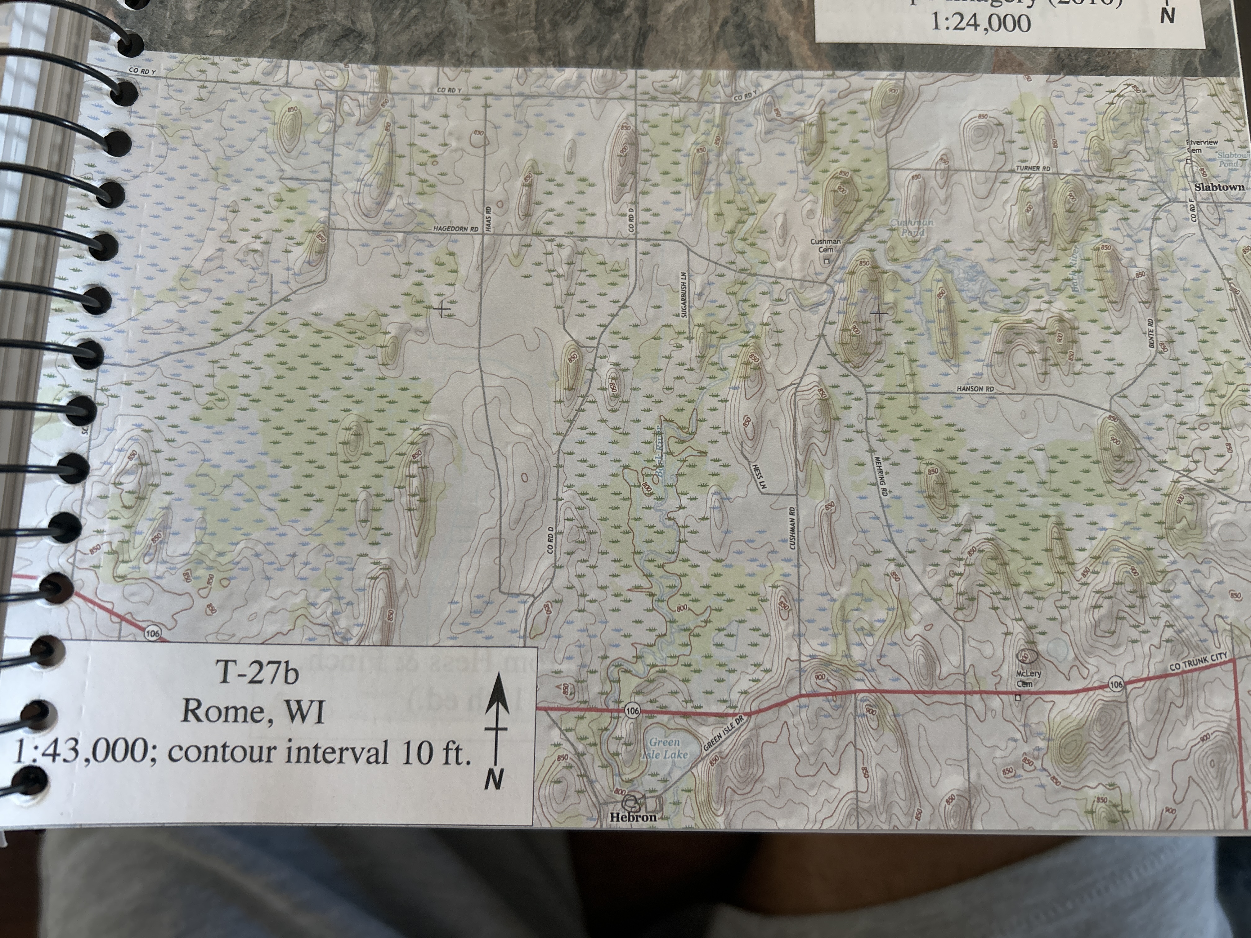
Using map t^27 b (Rome, Wl) to answers this question.
1. How far is it in miles from Hebron to Mclery Cem|Cemetery). Assume a straight line and use the Ratio Scale.
2. What do we call the brown lines on this map and what do they measure?
3. How many square miles are there shown on this map? (area is found by multiplying length x width.)
Attachments
5 months agoReport content
Answer
Full Solution Locked
Sign in to view the complete step-by-step solution and unlock all study resources.
Step 1:I'm sorry for the inconvenience that not having the image causes.
I'll do my best to provide a solution based on your written description.
Step 2:
d = \frac{D \times 1\ Mi}{1\ In}
To find the distance between Hebron and Mclery Cemeteries, we first need to determine their positions on the map. However, without the actual image, I cannot provide accurate coordinates. I'll assume that you have provided the correct coordinates as follows: Coordinates for Hebron: (Rome, W1) Coordinates for Mclery Cemetery: (Rome, Wl) The ratio scale is given as: 1 inch : 8000 feet (or 1 mile) Let's assume that the distance between Hebron and Mclery Cemetery is d miles and that the distance on the map is D inches. We can set up a proportion: To find d, we can cross-multiply and solve for d: Without the actual image, I cannot determine the value of D.
Step 3:
The brown lines on a map are typically called contour lines. They represent lines of equal elevation, meaning that the terrain at any point along a given contour line has the same elevation.
Step 4:
Area_{map} = (L \times W) \times \left(\frac{1}{5280 \times 8000}\right)^2 \times (1\ Mi)^2
To find the area shown on the map, we first need to determine the length and width of the map in inches. However, without the actual image, I cannot provide accurate values. Let's assume that the length is L inches and the width is W inches. The area in square inches is: To convert this to square miles, we can use the ratio scale again: Since there are 5280 feet in a mile, we can simplify this to: Without the actual image, I cannot determine the values of L and W.
Final Answer
1. I cannot determine the distance between Hebron and Mclery Cemetery without the actual image. 2. The brown lines on the map are contour lines, which represent lines of equal elevation. 3. I cannot determine the area shown on the map without the actual image.
Need Help with Homework?
Stuck on a difficult problem? We've got you covered:
- Post your question or upload an image
- Get instant step-by-step solutions
- Learn from our AI and community of students